Hello, my dear readers!
I was not with you for several days, because... I went with my daughter to apply to universities in our regional city of Yekaterinburg.
Documents were submitted to four universities, which were located in different parts of the city, and we would have had to spend a lot of time to find them, find out how to get there, if one smart program had not come to the rescue, which saved us a lot of time and allowed us to confidently move around city. This 2gis program.
And today I will be happy to share with you what it is 2gis cards and how to work with them, how you can download 2gis for free and for those who wish - download 2gis for Android and others operating systems smartphones.
2 gis are electronic directories containing maps of cities and organizations.
By selecting the city you need (if it is in the directory), you can see all the streets (with house numbers), transport and metro stops, all organizations with names, addresses, work schedules and other objects.
You can easily find out how to get from one point of the city to another by simply entering the departure point and destination (street and house or stop) in the fields.
On the left, the 2GIS program will show all the transport that goes on the route you specified, and on the map - the entire path of this route with all the stops. You can also select the “get there by car” tab and 2GIS maps will show you the best route for the car.
Before going to Yekaterinburg, I found all the universities on the map and chose the best route, as a result, we submitted documents to four universities in 4 hours (this includes the road). And then we made purchases, having previously selected the organizations we needed and knowing how to get to them, which also saved a lot of time. If it weren't for this program, I think I would have had to spend the whole day.
Let's go directly to the program.
2GIS maps contain more than 90 cities, including suburbs and surrounding areas. Work is underway on 2GIS projects in nine more cities.
You can download the 2gis program for free on the official website using this link http://ekaterinburg.2gis.ru/
You will be taken to a page where you can immediately download a map of Yekaterinburg. If you need another city, then simply click on the word “Ekaterinburg” at the top and, in the drop-down menu, select the city whose map you want to have at your disposal.
After that, click on the big blue “Download” button

After downloading, find the folder with the program, click on the file there and launch the Installation Wizard. Follow his steps - everything is clear there, in Russian, check the box when the Wizard asks you whether to create a shortcut on the desktop.
After installation, click on the program shortcut and open it.
First set the parameters (on the right top corner programs). There you can configure general settings (language, directory location, etc.). I recommend leaving the “Show tools” checkbox, then at the top you will have a panel with tools like this

And you can quickly take the necessary actions. For example, by clicking on the ruler, you can measure the distance between two or a series of points and the program will show how much it will be in minutes on foot.
By clicking on the second tool - radius, you can determine the radius of the search for organizations in meters and minutes on foot.
By clicking on the third tool - 3D, you can turn on and off the three-dimensional image.
If you want to install another city, then next to the “Settings” tab, select the “Update Center” tab, check the box next to the desired city and “Install”.
Maps are updated automatically. The Update Center itself will let you know that you need to enable the update, it will open a window and you just need to check the boxes and click on the “Install” button.
When you click on “Catalog” (in the upper left corner), a catalog of all organizations in the city will open on the left or right (as you configure the location of the directory in the parameters). By clicking on the desired organization, you will see its activities, address, opening hours, and its location on the map (if it is a network, then the entire network of this organization).
You can find any object on the map by typing in the “What” field - the field of activity, name or telephone number, or in the “Where” field - the name of the street, stop, neighborhood and clicking the “Find” button. If, suddenly, you were unable to find an object in the main search, then select “Advanced search”.

If you need to find out how to get from one point of the city to another, then in the next section, in the “FROM” field, enter the name of the street, house or stop (when you enter, hints will pop up to help you choose necessary information, you need to click on the desired option), in the “TO” field - the final destination. And click on the word “Find”, here you will be asked to choose city transport or a car.

If you choose city transport, then on the left (or right) in the directory window numbers and types of transport will open that will help you get from one point to another. If there are transplants, then all information about them will also be given.
![]()
By clicking on the route number, the map will show the entire route of this transport with all stops.
If you choose a car, then the directory window will provide all the information on this route

and the map will show the entire route.
And further. If you have several cities loaded, you can move from one to another by clicking the small “Open another city” button in the upper left corner  and click on the name of the desired city. Other 2GIS cards will open, i.e. You can immediately open maps of several cities at the same time.
To download 2gis for Android and smartphones with operating systems iOS systems, Symbian, Windows Mobile, Windows Phone, return to the site from which you downloaded the 2gis version for your computer. Scroll just below the blue “Download 2GIS” button and see this picture
Click on the link “For mobile phone" and on the next page on the left to the link "More about 2GIS for phones", you will be redirected to a page where you can familiarize yourself with the installation of 2gis for Android and other operating systems.
I myself have not installed this program on my phone, so I cannot describe this process. But I think that you will figure everything out just fine on your own!
So, friends, you and I got acquainted with such a wonderful program as the 2GIS program, we learned what 2GIS cards are and learned how to work with them, we were able to download 2gis for free on a PC and on a phone.
I wish you to easily navigate in any city, quickly find the necessary information on organizations and save your time!
With sincere and deep respect to you,
Long gone are the large, thick reference books that you had to tirelessly leaf through in order to find the information you need. All sorts of online guides have become a worthy replacement, and one of them is 2GIS.ua, thanks to which you can find beauty salons, restaurants and shopping centers. Obtaining the necessary data and searching for the desired item takes a minimum of time. At the same time, using the card is simple and convenient.
What is 2GIS? This is an acronym that stands for geographic information system+ city information directory.
Development of the project began in 1999 by the Tekhnograd Plus company, and by 2004 it became an independent unit. The card has gained enormous popularity that today it is used not only in our country, but also abroad.
How to use 2GIS
To start using 2GIS, you just need to go to the website or download the application for your smartphone. You can use the service on platforms such as IOS, Android and Windows. After you visit the site, the application will ask you to select the city in which you are currently located. In addition, users have access to the “Locate my location” option, with which the program itself will indicate your coordinates.
What other options are present on 2GIS.ua maps?
- The “Traffic” service, which determines the level of congestion on highways in a specified unit of time. Using this option, you can create a route that bypasses all traffic jams in the city.
- The “Scale” function, which will allow you to examine in detail each section of the path, turn or house.
- A “ruler” with which you can measure the distance from one point to another.
- "Layers" function. Thanks to this option, you can view not only a map of the city, but also its surroundings.

Using 2GIS maps, you can easily and in a matter of minutes plot a route from one point to another. You also have the opportunity to choose any type of transport, on which you plan to travel. The option is especially useful for those who want to walk around an unfamiliar city or area.
2GIS Directory
The second direction of the company is information and reference support for the population. Today, this is the most convenient functionality designed to search for information of interest. Compared to regular maps, when using the service you have access to the most current and detailed information about the organizations you need. What data can be obtained using the 2GIS.ua directory?
After entering the name of the organization in the search bar, for example, “beauty salon,” you will have access to all the information about the beauty salons available in the city. Data is reflected in graphical form, and you can choose those points that are located near your home, work, or study.
In addition, the service has a special filter with which you can find an organization that meets all the requirements. How to do it?
- Filter by open/closed type.
- Indicate additional services that the organization should provide.
- Clarify the price range for services that is acceptable to you.
- Check the availability of the company website.
- Find out if the establishment allows you to pay by card.
- Find out about current discounts.
Once a suitable organization is found, you will be able to obtain all available information about it without leaving the site. The following information will be displayed in the window that opens:
- Address, phone number and opening hours.
- Is the company currently open?
- How to get to the organization, and on which side the entrance is located.
- Range of prices for basic services.
- The site of the company.
- Availability of parking spaces.

You can use the map and directory anywhere in the city from your phone, tablet or desktop PC. This is one of the simplest, most convenient and quick ways search for the desired geopoint. Information services are provided completely free of charge.
2GIS / 2GIS– an electronic directory of organizations that contains information about more than 350 cities in 9 countries (Russia, Ukraine, Kazakhstan, Kyrgyzstan, Italy, Cyprus, UAE, Czech Republic and Chile). These are city maps and full base data about each institution or organization in the city. 2GIS in Russian regularly updates its databases so that the information is always relevant to the user. You can find the object you are interested in by name or address, or find it in a certain category. In addition, if this object operates on a schedule, it can also be found in the directory. You can also search for ordinary houses or buildings.
2GIS on your computer has accurate city maps, using which you can find the shortest route to a given point, determine which transport will take you to it, and find public transport or metro stops nearby. All settlements, districts, streets and blocks are marked by boundaries. 2GIS / Double GIS for Windows 7, 8, 10 allows you to make notes on maps or directories. There are also posters for theaters and museums. Upload to 2GIS online additional layers, and look for hotspots of free Wi-Fi, web cameras, and various city attractions.
2GIS can work without access to the Internet, since all databases with all the information are already downloaded on your device. Just update them periodically to keep the information current. In the Double GIS database you can find cities such as: 2GIS Moscow, Novosibirsk, Perm, Krasnodar, 2GIS St. Petersburg, Chelyabinsk, Nizhny Novgorod, 2GIS Yaroslavl, Barnaul, Tyumen, 2GIS Samara, Krasnoyarsk, Omsk, Tomsk, etc. With us You can always download 2GIS for free to the site / 2GIS 2019 on computer via a direct link from the official website without registration and SMS.
Main features of 2GIS for Windows 7, 8, 10:
- Big information base for 340 cities around the world;
- Ability to work without access to the Internet;
- Quickly search for objects in different categories;
- Ability to create routes using transport;
- Ability to load additional layers.
2GIS (DoubleGIS) is a free multi-platform geographic map and navigator with a lot of additional features.


Download 2GIS - an excellent free map database with well-organized navigation and a search system for the necessary organizations, which makes it possible to confidently navigate and move around the area.
Distinctive features of the application:
- works without the Internet: plots a route, searches for addresses (restaurants, gas stations, pharmacies, etc.);
- lays out pedestrian, transport and cycling routes;
- convenient and understandable user interface;
- many cities in different countries: Moscow, Rostov-on-Don, Tashkent, Dubai, etc.;
- multidisciplinary operating room support Windows systems, Android, iOS.
Compared to similar popular mobile navigators, 2GIS is truly implemented “for people,” as can be seen from the display of only current geo-data. The company’s employees conduct timely analysis and research of areas: how many roads have been repaired, how many houses have been rebuilt, etc. Changes for each city are included in the corresponding maps monthly.
Today, not only travelers, couriers and people who do not know their way around even in their own city are familiar with the 2GIS application.
Given software tool 2 GIS, which, by the way, is adapted for a wide variety of mobile platforms, can be useful to anyone. If earlier the utility was positioned as a typical local tool, mainly used to search for stores, today it is a high-quality software system with full-fledged maps and a lot of useful data that will not let you get lost.
The main feature of the navigation system is the ability to work offline without the Internet, so there is no need to spend megabytes of traffic or look for Wi-Fi access points. The user simply needs to download the map of the required city and use it everywhere.
Geolocation data from 2 GIS contains not just the names of streets, boulevards, squares and attractions, but also information about organizations (entertainment, administrative, shopping and others) of the city. To determine the location, just go to the appropriate section of the client and find the necessary cafe, store, hospital, cinema, etc.
Download 2GIS for free on your computer for Windows, or on mobile device Android, iPhone or iPad, and everything Windows smartphones Phone. Discover one of the best urban mapping systems with excellent information content, a pleasant navigation engine and the ability to use both a map and a directory at the same time.
With 2GIS you can easily determine your location, navigate the locality and find the necessary information on organizations.
2gis is a modern interactive map that includes a completely free directory of organizations. On the 2GIS map you can find information about any company in your city, as they constantly update, check and expand their database of organizations. 2gis unites 8 countries, 282 cities, 9.5 thousand settlements and almost 2 million companies! The numbers are truly impressive, and this company does not stop growing.
Thanks to the convenient and simple functionality of 2GIS cards, the number of their users is constantly increasing. Therefore, we strongly recommend you.
The 2gis map widget shows the following information about your organization:
- Detailed address;
- Telephone;
- Opening hours;
- Possible payment methods for services.
The “Find entrance” button will be useful, especially if the house you are in has several entrance doors: the client will know which side and where to enter. And with the help of the “Way from here/here” buttons, your users will be able to plot a convenient route by car or public transport.
Step 1. Get the code to install the 2gis card on the website
To install an interactive 2GIS map on your website, you first need to get its html code. To do this, go to the API section of the 2GIS website and click the button "Create widget".
Then select the desired city (2gis will automatically suggest the locality in which you are located), enter the name of your organization in the input window.

The directory will offer you a list of organizations with a similar name. Select yours and click the button "Further".
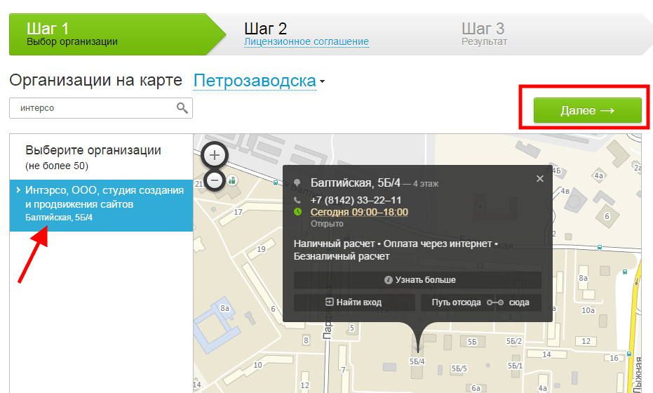
Check out license agreement, if you are satisfied with everything, then check the box to accept the terms and click the “Get code” button.

Copy the proposed code to install the 2gis map on the site.

Step 2. How to insert the 2gis card code into the website
So, the code has been received, all that remains is to place it on the desired page of the site. We decided to add a map to the “Contacts” section. Go to the Nubex admin panel, select the section on the control panel "Pages", find the desired section in the list and click "Edit".

We will work with a text block. Press the button "Source" to switch to code editing mode. Paste the code received on 2GIS into the text field and save the changes.

We go to the “Contacts” page of our website and enjoy the updates!

Maps on the site are a useful thing: you don’t have to explain for a long time to clients how to get to the office, where to go and where to turn off. We also advise you to familiarize yourself with similar services from Google and choose the one that suits you.